 |
THE GREEN FLASH
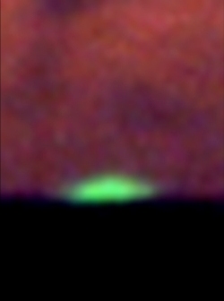
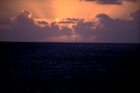
Yes—The Green Flash is Real! Green "flashes" are an atmospheric phenomenon associated with the setting (or rising) Sun, usually for no more than a second or two. So, the term "flash" is often incorrect. (They can also occur with other celestial objects.) This phenomena can stem from different causes but results from variations in atmospheric refraction and are related to mirages. (See, for example, Explaining Green Flashes.) They are not often seen and can be difficult to photograph. They are usually most easily seen over an unobstructed horizon (as over the ocean), but are possible to view elsewhere. Even rarer blue flashes can also occur. (Also see enlarged photo below). Location: Ms Paul Gauguin • South Pacific Ocean. Photo Taken: 2005 April 7.
|
|
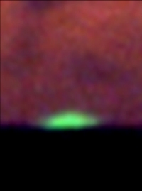 |
GREEN FLASH ENLARGED
Green Flash at Sun's Upper Limb. Color has been slightly enhanced in this enlargement made from above frame. This green flash was both visually seen and photographed during a sea adventure to observe the 2005 April 8 total solar eclipse. Location: Ms Paul Gauguin • South Pacific Ocean. Photo Taken: 2005 April 7.
|
|
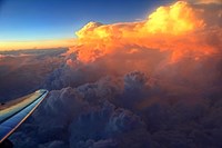 |
TOWERING CUMULUS CLOUDS AT SUNSET
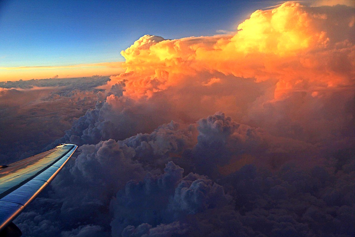
Towering Cumulus Congestus and Cumulonimbus Clouds at Sunset from Thirty Thousand Feet. American Airlines Flight #574 from Ft. Worth/Dallas, Texas to Jacksonville, Florida from about 30,000+ ft. (9,144 m) somewhere over south central Mississippi on May 2, 2010. These rapidly building clouds came into view as we passed above an area of unstable air. Note their reflection on the port-side wing. Photo Taken: 2010 May 2, 07:41 p.m. CDT. Photo Details: Canon DSLR, EOS 5D Mark II; Canon 28-135 mm lens; f/3.5-5.6 USM at 30 mm; Equiv. ISO 400; 1/125 seconds exposure at f/4.5, white balance at Auto. Posted: On EPOD (2010-06-11)
|
|
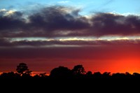 |
RED SUNSET GLOW
Clouds and a Very Red Sky. Photo taken while looking for a very young crescent moon low over the western horizon, 2012 October 16. Clouds hampered search for the thin crescent which was finally captured in one picture frame. (See "Spot the Crescent" under Moon Photos.)
|
|
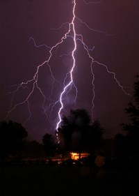 |
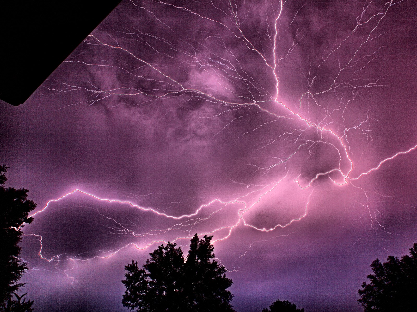
FLORIDA’S LIGHTNING ALLEY
A Fierce Bolt of Lightning. A fierce bolt of lightning from an early morning thunderstorm lights Gainesville skies. Photo taken from southwest Gainesville, Florida looking north toward Haile Plantation. Gainesville is on the edge of North America’s "Lightning Alley," the most active lightning region in North America.
(Do not confuse "Lightning Alley," with "Lightning Valley Motor Sports Park" in Junction City, Kentucky!)
Here, moist air surrounding the Florida peninsula moves inland and rises over land intensely heated by the summer Sun, regularly producing potent storms and often dramatic lightning displays. Most of the storms occur during the afternoon hours but nighttime storms are not uncommon.
Picture Taken: 2010 June 6, 01:42 a.m. EDT
Photo Details: Canon DSLR,EOS 5D Mark II; Canon 20-35 mm lens; f/3.5-4.5 USM at 20 mm; Equiv. ISO 200; 30 seconds exposure at f/16 white balance at Auto; image slightly cropped from original frame.
Posted: On EPOD (2010-07-06).
Appeared: On cover of USGS Circular: 1383-A, "U.S. Geological Survey climate and land use change science strategy: a framework for understanding and responding to global change," 2013, Burkett, Virginia R., et al.
|
|

Medium Size •
Large Size |
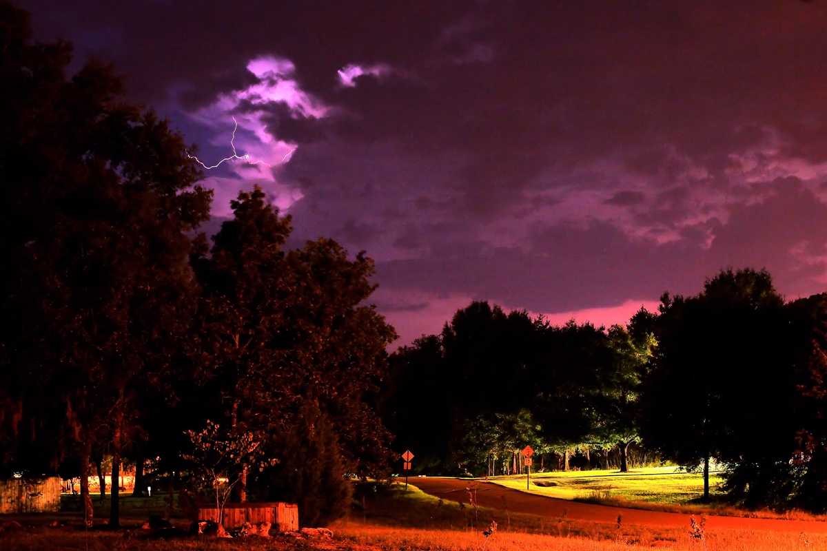
SUMMER SOLSTICE LIGHTNING
Lighting the Sky. Summer in Florida is not a friend to star gazers. Moist warm air rising over the Florida peninsular often brings extensive thunderstorms with abundant lightning, especially during afternoons and evenings. Active late evening thunderstorms brightly lit up north central Florida skies in the hours before midnight, 2014 June 20, about 7–8 hours before the June solstice (6:51 a.m., EDT June 21). Most lightning was cloud to cloud including sheet lightning that strongly illuminated the northern and western horizons from this location. Photo taken from southwest Gainesville, Florida looking northwest toward the cities of Alachua and High Springs. Picture Taken: 2014 June 20, 11:36 p.m. EDT.
Photo Details: Canon DSLR,EOS 5D Mark II; Canon 20-35 mm lens; f/3.5-4.5 USM at 28 mm; Equiv. ISO 200; 30 seconds exposure at f/11 white balance at Auto; image slightly cropped from original frame. Processed in Corel Paint Shop Pro X5.
Posted: On EPOD (2014-08-09).
|
|
 |
SHEET LIGHTNING
Intra-Cloud Lightning. Summer thunderstorms in Florida sometimes produce intra-cloud lightning well into the night. This "sheet lightning" may occur almost continuously and strongly illuminate the night sky for hours although the lightning bolts are usually hidden by the clouds. Photo taken from southwest Gainesville, Florida looking southwest as strong storms moved to the south passing west of Gainesville, Florida. Picture Taken: 2014 August 24, 1:14 a.m. EDT. Photo Details: Canon DSLR,EOS 5D Mark II; Canon 50 mm EF lens; f/1.8 USM; Equiv. ISO 800; 15 second exposure at f/4. Image slightly cropped from original frame. Processed in Corel Paint Shop Pro X5.
|
|
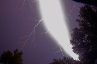 |
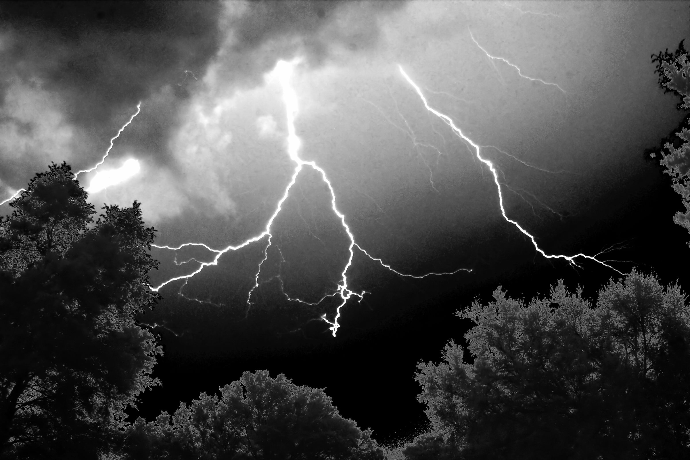
BRILLIANT LIGHTNING & LOAD THUNDER
Powerful Bolt Out of Nowhere. Picture shows a blinding and brilliant lightning strike accompanied by deafening thunder, so close that the thunder and lightning were simultaneous. Bolt so bright had to look away and thunder was deafening. Photo taken night of 21 Aug. 11 from 11:36:24 to 11:36:54 p.m. EDT. Location: S.W. Gainesville, Florida looking toward north. Photo Details: Canon 5D II, 28-35 mm at 28 mm (slightly trimmed), 30 sec at f/16. (ISO 200)
EDT.
|
|
 |
LIGHTNING FROM STRONG THUNDERSTORM
Late Winter Thunder Storm. A strong thunderstorm moved through North Florida about one week before the March equinox. Continuous sheet lightning brightened the the sky with load thunder during morning hours. Occasional lightning bolts darted from within the clouds illuminating trees to the north.
Photo Details:
Date: 2023 March 13, 3:22 a.m. EDT
Location: Meadows of Kanapaha II, Gainesville, Florida
Camera: Canon EOS 5D II on Fixed Tripod
Lens: Canon f/3.5-4.5, 20-35 mm at 35 mm
Exposure: f/8, 30 sec, ISO 800
Processed in Corel Paintshop Pro & Trimmed from Original
|
|
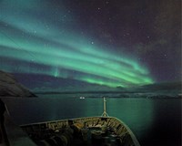 |
NORTHERN LIGHTS
Northern Polar Lights. Photos (Aurora Borealis) from Aboard Hurtigruten's MS Nordlys on Norway Coastal Voyage Cruise. Location: Above Arctic Circle, 2010 March 14–18. Photo Details: Camera: Canon DSLR EOS 5D Mark II with Canon 20-35mm, f/3.5-5.6 lens at 20mm. Click to see pictures. Exposure information below each picture.
|
|
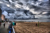 |
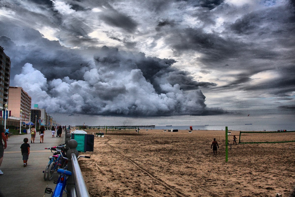
VIRGINIA BEACH STORM CLOUDS
Virginia Beach Storm Clouds Threaten Beach Lovers. Virginia Beach, Virginia claims to be the world's longest pleasure beach. Hundreds of hotels, motels and numerous restaurants line the beach. On this day evening summer storms menaced the beach. (Photo taken 2013 July 13, 7:43 p.m. EDT.)
|
|
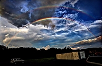
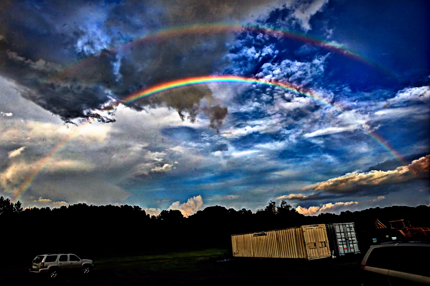
Rainbows are only visible opposite the Sun’s direction. Therefore, they are most easily seen during early mornings in the west and early evenings in the east. Low altitude of Sun helped extend visible arcs and some dark clouds helped make the arcs more conspicuous.
|
DOUBLE RAINBOW
Bright, Long Double Rainbow Near Sunset. Rain preceded an Alachua Astronomy Club star party revealing a rare, long double rainbow looking eastward with Sun 6.6 degrees above western horizon. This rainbow was a bit unusual because of its long arc (approx. 120 degrees) and visibility of a secondary rainbow about ten degrees above the primary arc. Notice most spectral primary colors (red, orange, yellow, green, blue, violet) are visible in primary rainbow. Also, notice inverted colors in fainter secondary rainbow due to a second reflection of light.
Light rays enter raindrops floating in air are refracted (bent) and reflect off the back of the raindrop. The amount of refraction depends on the light’s wavelength ("color"). This causes the colors to separate. Light leaving the rainbow is spread over a wide angle, with a maximum intensity at an angle of about 42 degrees. (The reversal in the light’s direction means rainbows are seen opposite the Sun.) A double reflection within the raindrop can cause a secondary rainbow at about a 50-degree angle. The second reflection reverses the order of colors and makes the colors fainter due to the added reflection. So, secondary rainbows are often not seen or are very faint.
Photo Details:
Location: Newberry Star Park, Newberry, Florida. Date: 2014 July 18, 7:55 p.m. EDT.
Camera: Canon DSLR,EOS 5D Mark II
Lens: Canon 20-35 mm, f/3.5-4.5 USM @ 20 mm
Exposure: ISO 400; 1/350 sec at f/11.
White Balance: Auto
(Photo slightly trimmed from original.
|
|
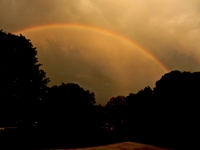
Photo Details:
2022 June 15, 7:42 p.m. EDT
Camera: Nikon Coolpix S9900
Exp.: 1/1000s @ f/3.7 (ISO 125)
|
ECLIPSE RAINBOW
A Rainbow Appears Before a Lunar Eclipse. Rain, lightning and thunder occurred in parts of North Florida on the eve of the 2022 May 15/16 Total Lunar Eclipse. This delayed setting up equipment to observe the eclipse.
However, by 9:00 p.m. EDT skies began to clear allowing views of the ensuing eclipse. This was preceded by the appearance of a rainbow just before the Sun set at 8:15 p.m. EDT, just before clearing skies.
See photos of this eclipse.
|
|
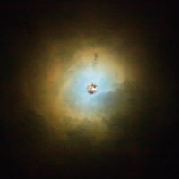 |
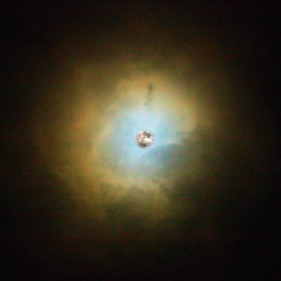
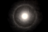
"LUNAR PLANETARY NEBULA"
Iridescent Clouds. The evening sky on 2016 December 13 displayed a third successive "super full moon." This perigee full moon was slightly larger and brighter than an average full moon although judging the difference would have been difficult.
However, the larger than average gravitational attraction between Earth and Moon produced higher than normal tides.
In fact, excessive gravity warped the Moon's interior causing the Moon's vapors to expand and eject from the lunar surface.
Thus, the Moon became a lunar planetary nebula! See photo at left (or larger version).
P.S. If you believe this, I have the Hubble Telescope to sell you.
This composite photo of the 2016 December 13 full moon actually shows iridescent clouds surrounding the moon resulting from moonlight scattering through similar, small water droplets.)
Location: Gainesville, Florida. Date: 2016 Dec. 13, Photo Details: Canon DSLR,EOS 5D Mark II; Canon 28-135 mm lens; f/3.5-5.6 USM at 135 mm; ISO 6400; White Balance on Auto. Trimmed from original. Clouds: 11:34 p.m. EST; 1/45 sec at f/5.6. Moon: 11:37 p.m. EST; 1/1000 at f/8.
|
|
(Click to Enlarge) |
"MOON HALO IN WINTER'S SKY"
A Ringed Moon in the Hyades. Passing clouds from an approaching cold front thinned and produced a nice moon halo. The Moon, shrouded in clouds, was in Taurus hiding the Hyades Star Cluster and Aldebaran. However, stars from Orion appear to the lower left with the halo's ring crossing near the belt of Orion. The Pleiades Star Cluster ("Seven Sisters") shows through clouds just to the right of the Moon. Mars appears to the lower right. Capella is the bright star at the top with stars from Auriga including the "Three Kids Triangle" at the outer edge of the halo.
See photo at left (larger version).
Location: Gainesville, Florida. Date: 2019 Feb. 13, Photo Details: Canon DSLR, EOS 5D Mark II; Canon 20-35 mm lens; f/3.5-4.5 USM at 20 mm; White Balance on Auto. Exp.: 10 sec at f/4, ISO 1000. Camera on fixed mount. Time: 7:26 p.m. EST.
|
|
|